COASTS
- The UN's physical landscape varies between upland and lowland Britain.
- The trees form a line that extends from the Trent estuary in the Northeast to the Exe estuary in Devon in the Southeast. It divides the upland and lowland areas.
- The height and shape of the sand dunes on the highlands depend on the geology and the processes that have acted on them, specifically:
- Past tectonic processes (plate tectonics)
- Past processes caused by glaciation.
- Current processes are influenced by the rivers and coast.
GEOLOGY
- There are three main types of rocks that make up the Earth's crust, and they vary in formation and hardness.
- The upland area is the most resistant rock form. They resist erosion with weathering.
- The lowlands of the UK consist of younger, less resistant sedimentary rocks.
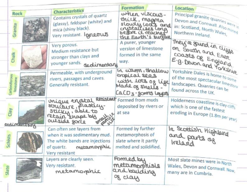
SEDIMENTARY: The landforms of the UK are composed of small particles that have either been eroded, transported, and deposited in layers or remained like plants and animals. E.g., chalk and limestone.
INEDUOUS: Volcanic activity forms the rocks when the magma or lava cools. The rocks are made of crystals, which are usually hard: e.g., granite.
METAMORPHIC: Existing rocks that have been changed by extreme pressure or heat.
Usually, they consist of layers that resemble banding in clay or metamorphic rock, such as slate.
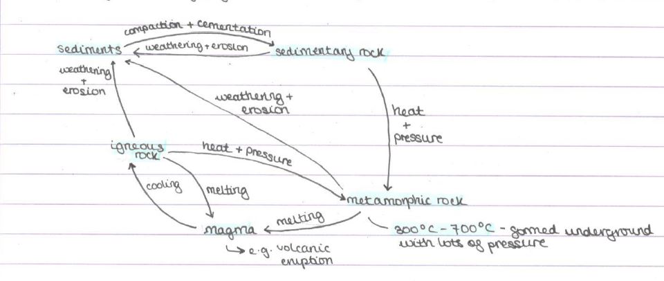
- The older the rock, the stronger, harder, and more resistant it is.
- Towards the highlands—N, NW (Scotland)—there are more igneous and metamorphic rocks, indicating that they are older, mountainous, and have high reliefs.
- There are also older sedimentary rocks providing higher relief, e.g., Cambrian rocks. We found this in Wales and North England.
TECTONIC PROCESSES
- Some of the rocks in the UK are volcanic in nature. There aren’t any active volcanoes in the UK today, but there must have been in the past. Therefore, the rocks formed during this period are extremely old and resistant to erosion.
- Upland areas could be caused by past tectonic processes and resistance activities. Previous plate movements and tectonic activities carried sediments in the rocks due to uplifting and tilting along previous faults.
GLATIATION
- Climates—past and present—have affected the landscape. The last time was in the Pleistocene period, where there was a succession of glacial and interglacial periods.
- The most recent ice age, over 10,000 years ago, brought huge glaciers and had 3 aspects:
- Altering river valleys, making them deeper and wider. V-shaped valleys → U.
- As they melted, they left behind glacial features, e.g., Malham Cove in the Pennines.
- Boulder clay, a type of sedimentary rock, was laid down by ice sheets in much of Eastern England.
Glacial Features
RIBBON LAKE
- You can locate it in the Lake District.
- It's a large, narrow lake that occupies a U-shaped valley.
- Occasionally, it appears as though glaciers have deeply eroded the less resistant rock. Alternatively, it could seem as though a wall of moraine has been formed across the valley.
CIRQUE
- Looks like an amphitheatre. These starting points frequently display comets and cayes, accompanied by glaciers.
- Snow walls are then compressed due to pressure or more layers of snow over thousands of years into glacier ice storms.
- Erosion and weathering will gradually make the hollow bigger; their ice wall is in circular motion. Gravity = rotational slip.
- For these glacial features, the dominant form of erosion is abrasion. However, plucking and freeze-thaw weathering also occur.
- They are found in colder places—upland areas are evidence of glaciers.
SUMMARY
- Millions of years ago in Britain, there were many active volcanoes and plate. movements that caused massive gods and gaults, shaping the landscape today.
- Softer and younger sedimentary rocks, less resistant to erosion, form many lowland UK landscapes. These are gorges of clay + chalk in SE England.
- The harder, resistant rock types that form upland UK areas have eroded more slowly than lowland rocks. These include igneous and metamorphic rocks found in Scotland, the Lake District, and parts of SW England.
- Harder sedimentary rocks, such as carbonigenous limestone, form certain upland areas and are less resistant to erosion. E.g., carbonaceous limestone. 250-350 mya when plants. When plants and sea creatures died, the calcium in their shells and skeletons built up layers on the seabed, forming rocks from calcium carbonate.
Rock Types
CHARACTERISTICS OF ROCKS
LAKE DISTRICT
- GEOLOGY HIGHEST POINTS: The upland area, located at 978 m above sea level on Scafell Pike, contains both igneous and older sedimentary rocks.
- LANDSCAPE: There are U-shaped valleys filled with ribbon lakes, abundant rock fragments, scree, and rugged, steep, and jagged terrain.
- ICE AGE SLOP PROCESSES: Glaciers formed U-shaped valleys, ribbon lakes, cirques, hollows, and misfit rivers. Rockfalls are characterised by unstable, easily moving scree fragments, which pose a significant risk to hikers when large rocks break and fall. Landslides: Rain adds to the weight of weathered rock in the wettest region of the UK, which means it dies easily. There's over 2000 mm of rain per year.
- WEATHERING PROCESS: Freeze-thaw weathering.
- OTHER INFO: Land is fertile for farming due to the deposition of alluvium, silt, and mud.
Lowland WEALD
- GEOLOGY HIGHEST POINT: Once a dome of solid rocks, growing an arch called an ‘enclume’ made of chalk. At 225m above sea level, small, gently rolling hills provide habitats.
- LANDSCAPE SCOPE PROCESS: There are deep slopes and vales made of softer clay, rolling hills, and no lakes. Soil creep: Soil creep is caused by rain dislodging soil particles.
- ICE AGE: As the climate warmed, underground waters heated through the chalk again, leaving dry valley beds.
- OTHER INFO: Antimerite erosion led to a scrape in the landscape and the formation of dip slopes where the rock eroded gently.
HUMAN ACTIVITY ON LANDSCAPES
E.g., South Downs National Park
AGRICULTURE
- Arable farming allows for the growth of wheat and barley.
- Chalk grassland is ideal for grazing sheep and training horses as it's short and rich in nutrients.
- Approximately 1100 farm businesses occupy 85% of the national park.
POSITIVE IMPACT
- Income from farming supports the local economy—6% of employment in the park.
- Arable farming supports rare birds like skylarks.
- Formation of hedgerows and field margins provides wildlife corridors for bats.
NEGATIVE IMPACT
- Decline in arable farming: Changes in farming practices lead to a reduction in the presence of arable plants, which in turn damages wildlife habitats.
- A decline in traditional practices, such as sheep grazing, results in the encroachment of scrub on remaining chalk grassland. in the remaining chalk grassland.
- Chemicals used in farming have caused a significant decrease in chalk grassland.
FORESTRY
- There's a widespread mix of deciduous and coniferous woodland that covers 23% of the park.
- Human activity in the UK is clearing large areas of woodland.
- The west part of the park is more wooded, resulting in an uneven distribution of trees.
POSITIVE IMPACT
- Large % comprised of ancient trees. It serves as a home for a wide variety of animals.
- Harvested timber from the park is valuable and sustainable, with growing markets in construction and fuel for heating.
- There are igneous rocks on the upland edge of sea level – Seashore Puffins.
NEGATIVE IMPACT
- Removal of woodland for new developments threatens some ancient large-leaved lime woodland. This woodland may closely resemble post-glacial wildwood ≈ 600 ya.
- Traditional management of many hazel and chestnut coppices has ceased, leading to a decline in the quality of the woodland and its biodiversity.
SETTLEMENTS
- Chalk escarpments that make up the ridge and valley scenery were suitable for development as spring-line settlements.
- People built settlements on the naturally formed south slopes, which provided defensible shelter.
POSITIVE IMPACT
- The most populated national park is home to 120,000 residents.
- Lewes and Midhurst are the largest market towns of any UK National Park.
NEGATIVE IMPACT
- Recent development that doesn't reflect local character has led to the loss of local distinctiveness.
- Many historic structures have been replaced, e.g., signposts from wooden to metal.
- There is a decline in community sacrifices such as pubs, post offices, and general stores.